

OpenStreetMap and the Digital Communities Trilemma
Why the best map in the world is also inconsistent by design...

I have spent more hours than I care to admit debugging tag conflicts in OpenStreetMap (OSM) data for Indian road networks. The same highway, physically identical, on the ground, verified tagged four different ways across four adjoining districts. highway=track, highway=unclassified, highway=tertiary, highway=road. All technically permitted. All inconsistent with each other. None of this is an accident of poor management. It is the structural consequence of a specific institutional choice and understanding it requires taking the trilemma seriously.
The conventional wisdom on digital communities holds that Openness, Activity, and Quality cannot coexist simultaneously. Gaining two requires sacrificing the third. This is not a hypothesis about particular communities or particular failures of execution. It is a structural claim about the design space available to any group of people attempting to build a shared knowledge resource through voluntary, distributed contribution. OpenStreetMap is the sharpest available test of whether the claim holds and, more usefully, of what happens when a community makes the trade-off honestly.
The Digital Comunities Trilemma
The three properties are worth stating precisely, because each is doing real work.
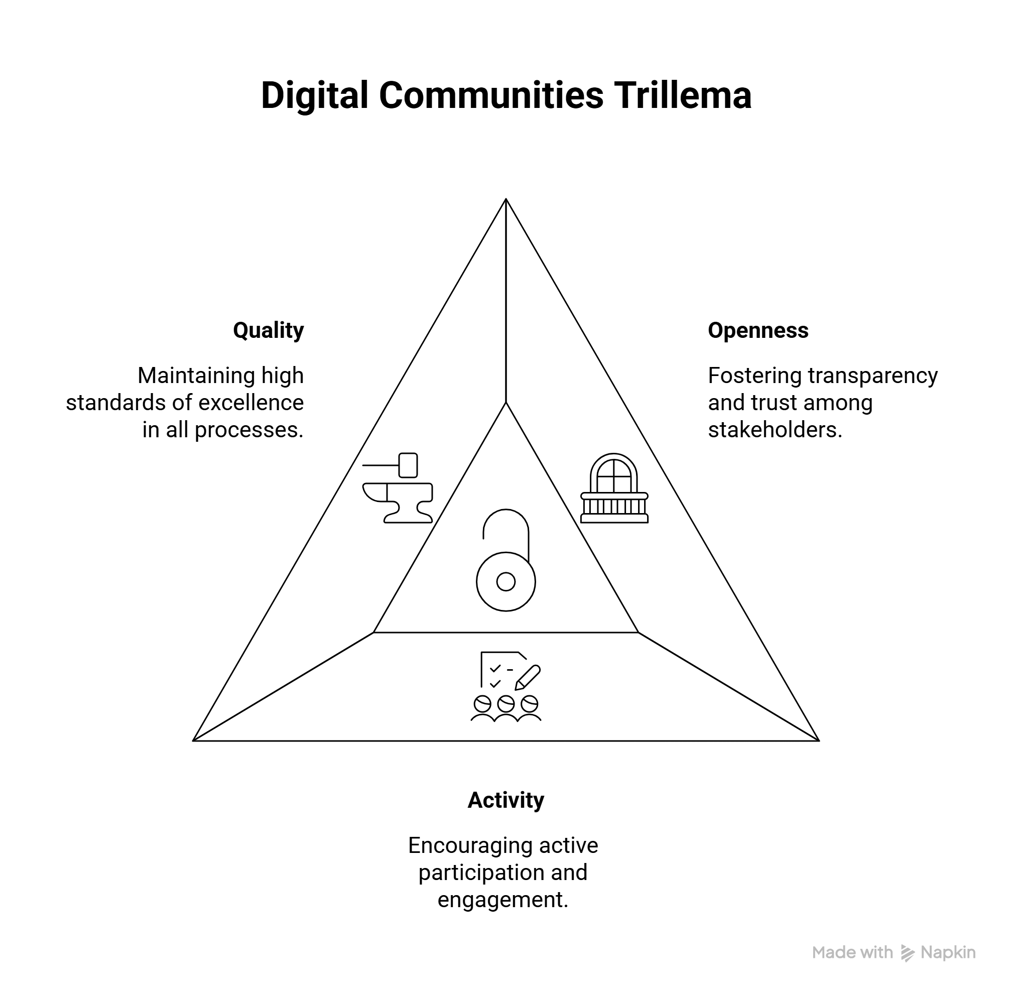
Openness means that participation is permissionless: anyone can contribute without prior credentialing, approval, or gate-keeping. The barrier to entry is intentionally low.
Activity means that the contributor community is large, engaged, and geographically distributed that the resource is actively maintained, updated, and expanded rather than left to stagnate.
Quality means that the artifact has consistent internal standards: a unified schema, shared ontology, predictable accuracy, and coherent structure across all its parts.
The trilemma follows from the interactions between these three properties.
Openness - Activity: Permissionless contribution at scale. Produces contributors with heterogeneous standards, conventions, and ontologies. Coherence disintegrates at the boundaries between communities. Quality suffers.
Openness - Quality: High-standard, consistent contribution requires either that all contributors independently converge on the same standards (which does not happen at scale) or that some authority enforces convergence (which constrains who can contribute and how). Activity is suppressed or redirected.
Activity - Quality: A dense, engaged community producing coherent output requires governance mechanisms that limit who contributes and what they contribute. Openness is the casualty.
Each pair of properties, held together, implies a sacrifice of the third. This is not a consequence of bad institutional design. It is a consequence of the geometry of the problem.
OSM’s Bet
OSM was Steve Coast’s 2004 answer to a specific British grievance. Ordnance Survey data was publicly funded, expensively licensed, and legally encumbered. The solution he imagined was a map that no government could capture and no company could hold hostage. A cartographic commons produced by voluntary contributors, owned by no one, available to everyone. The institutional choice followed directly from this ambition: OSM would maximise Openness and Activity, and accept whatever Quality deficit resulted.
Twenty years on, the bet looks vindicated. OSM has over ten million registered contributors. It underlies Apple’s pedestrian navigation, Meta’s humanitarian mapping, UNHCR’s refugee camp planning, and thousands of civic and commercial applications worldwide. The Activity dimension is unambiguous: OSM is one of the most actively maintained geographic databases on earth, updated continuously, in real time, across every inhabited continent.
The Quality deficit is equally unambiguous. The same physical feature such as a hospital, a river, a rural road may be tagged in seven different ways by seven different communities. Completeness varies wildly by geography, by contributor interest, by the accident of which local community happened to run a mapathon five years ago. The trilemma held its ground: Openness and Activity came at the cost of Quality, precisely as advertised.
How OSM Works Around the Deficit?
OSM has not ignored the Quality problem. It has developed institutional mechanisms to manage the deficit but not resolve it, manage it. The distinction is important.
The OSM Wiki functions as soft law. Tags are proposed, documented, and adopted voluntarily. Taginfo tracks usage rates across the global dataset. Legitimacy accrues through adoption, not decree which is closer to Hayekian price discovery than to legislative mandate. A tag that is used by enough contributors in enough geographies acquires a kind of de facto standard status. A tag that is used only in one region remains local convention. The system is self-organising rather than centrally administered.
The Data Working Group functions as a court of last resort: the minimum central authority needed to prevent commons tragedy, applied only when local mechanisms have failed. Edit wars, vandalism, and organised misrepresentation occasionally require adjudication above the community level. The DWG handles this without assuming editorial authority over the map’s content. Governance is reactive, not proactive.
Downstream consumers impose their own Quality layer through normalisation pipelines. When Overture Maps, Microsoft, or Meta ingests OSM data, they run it through transformation and validation scripts that impose the quality OSM cannot enforce at the source. The raw OSM layer is wholesale. Usable maps are retail, assembled downstream. This is efficient: it allows the Quality investment to be made by the party with the strongest incentive to make it but it means the Quality benefit does not flow back into the OSM commons.
Finally, the iD editor nudges new contributors toward dominant tagging conventions through interface design rather than governance. The platform is opinionated; the protocol is not. Soft nudges substitute for hard mandates at the point of entry, where the Quality gap is widest. New contributors are the least likely to know existing conventions and the most likely to introduce inconsistency.
Each of these mechanisms reduces the Quality deficit at the margin. None of them resolves the trilemma. The gap reasserts itself most visibly where the mechanisms are thinnest, which, structurally, is where the underlying need for good geographic data is greatest.
The India Story…
India sits in an unusual position in this story. For decades after independence, the Survey of India treated geospatial data as a national security asset, an institutionalised preference for controlled Quality over Openness or community Activity. Ajay Shah’s 2009 diagnosis was that this had become economically self-defeating: you cannot build a digital economy on location intelligence if the underlying data is legally inaccessible and perpetually out of date. His prescription was blunt: either reform the Survey of India’s release strategy to match the openness of the US government’s approach, or shut it down and redirect its annual budget of roughly Rs. 200 crore toward OpenStreetMap, which was actually producing public goods.
The 2021 Geospatial Data Policy was the belated legislative correction, dismantling the prior-approval regime, allowing private and community organisations to collect and publish maps freely. The Openness dimension of the trilemma, at the national policy level, was addressed. But the 2021 Policy could not address the Activity dimension in the geographies that matter most for development.
The OSM contributor community in India is large and engaged in cities. Bengaluru, Pune, and Delhi have active mapping communities; the OSM map in these cities is dense, well-tagged, and regularly updated. The Quality delivered by that Activity is visible. But in rural Jharkhand, the Northeast, remote Rajasthan, and rain-shadow Maharashtra the geographies where PMGSY road monitoring happens, where flood modelling is needed, where agricultural logistics depend on accurate network data, the Activity is thin. Where Activity is thin, Quality collapses, regardless of Openness. The trilemma is not a policy problem. Policy can deliver Openness. It cannot manufacture Activity.
This is where the Ostromian insight becomes relevant. Elinor Ostrom established that communities can sustain common pool resources without privatisation or state control but only when certain institutional conditions hold, including community density sufficient to generate and enforce reputation. Self-governance requires a community dense enough for reputational incentives to function. In India’s data-sparse geographies, that density does not exist. Openness is present; Activity is not; Quality cannot follow. The trilemma operates at granular geographic scales, not just at the level of national policy.
What This Implies for Design?
The trilemma is a tool for clear thinking. Its value is in forcing explicit choices, and in holding communities accountable to the choices they have made. The worst institutional outcome is not choosing a vertex and accepting the cost. It is claiming all three vertices while delivering none. The organisation that presents itself as Open, Active, and high-Quality, and delivers mediocre performance on all three because it refuses to make a genuine trade-off.
The design implications follow from the three pairs.
a. Communities that need Openness and Activity: cartographic sovereignty, civic knowledge bases, community archives should choose the OSM position. Accept the Quality deficit. Invest in downstream normalisation. Build soft-law mechanisms for tag convergence. Do not pretend the deficit does not exist.
b. Communities that need Openness and Quality: formal scientific databases, regulated reference data must restrict Activity. Gate contribution through credentialing or review. Be honest about this. Do not describe a credentialed contribution system as an open community.
c. Communities that need Activity and Quality: professional knowledge networks, institutional data pipelines must restrict Openness. Accept that permissionless participation is not compatible with the standards you need. Design accordingly.
For India specifically, the right response to OSM’s Quality deficit in data-sparse geographies is not to impose centralised governance that would surrender the Openness and Activity that make OSM valuable. It is to invest in local contributor community development, building the Activity density that the trilemma requires for Quality to follow. Humanitarian OpenStreetMap Team and YouthMappers have demonstrated this approach in other low-density geographies. Dense communities produce coherent data. The trilemma does not bend, but the cost of the chosen trade-off narrows when the community that bears it grows.
OSM made its choice in 2004. Openness and Activity; Quality as the acknowledged sacrifice. The choice has held for two decades. Its data powers humanitarian response in disaster zones, urban planning in organizations without GIS budgets, who have no idea they are riding on a commons.
The trilemma was inescapable. The choice was not. And looking at what that choice produced, it is hard to argue the ticket was not worth the price.
The Digital Communities Trilemma is based on a concept discussed during the Postgraduate Program at Takshashila Institution. Ajay Shah’s 2009 Financial Express piece on map data as a public good, Elinor Ostrom’s Governing the Commons, and Yochai Benkler’s The Wealth of Networks. The India-specific observations draw from years of working with Indian geospatial datasets. The OSM tag frustrations are personal.
Insightful about practical implications of OSM and how the eco system works to resolve the deficiencies.